


Indoor mapping: Woosmap offers location-based navigation experiences in private spaces
Interview with Jean-Thomas Rouzin, co-founder and CEO of Woosmap, the European leader in location-based search APIs and an indoor mapping pioneer.
Can you briefly present Woosmap?
Woosmap is the SaaS location-based platform for businesses, designed for developers. We’re the European leader in location-based APIs for B2B2C mobile applications and websites: our clients are businesses which work with consumers.
The Woosmap location-based search engine has three main features:
- Geographical search: browse user data for information of interest to you.
- Distance calculation: sort search results by road accurate distance or by Estimated Time of Arrival (ETA), thereby providing an optimal user experience.
- Mapping: integrate an accurate and intuitive navigation map into a user interface.
Protecting personal data is very important to us. Our platform does not collect any personal data and all Woosmap services comply with the General Data Protection Regulation (GDPR).
We provide solutions to meet our clients’ varying needs in terms of geolocation, from geofencing to navigation assistance within a private space, otherwise known as Indoor Mapping.
Can you explain the concept of indoor mapping?
Over the past decade, various companies including Google Maps have worked hard to improve the digital experience of GPS navigation in public spaces. We all use our smartphones to arrive safe and sound (and, ideally, on time). However, guidance always comes to an end in front of the store or the train station, at the entrance to the hotel or the theme park. Indoor mapping is a natural extension of traditional geolocation in various types of premises, providing users with an impressive level of precision and various additional services.
The main aim of indoor mapping is to guide the user to save time. But in reality, it can be used in many different ways. A few examples:
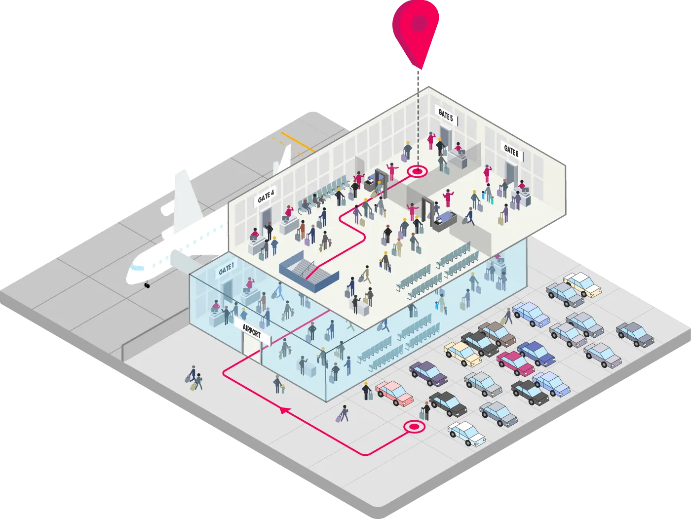
- Guiding people at the airport from their parking space to the boarding gate
- Improving accessibility for disabled people in a rail station or a department store
- Optimising routes for staff as they prepare orders in a hypermarket
- Connecting people who need assistance with station staff by helping them to find each other on a station platform
- Helping event attendees to reach a meeting room or meeting point
Let’s take the example of an airline which wants to improve its user experience by helping its “frequent flyers” to optimise their travel time. With indoor mapping, the app tells the user how long it takes to get to the airport, but it also tells the user how long it takes to get from the entrance of the airport to the boarding gate. The app sends the frequent flyer a notification to remind him/her to leave the office on time and even reserves a parking space for him/her, before guiding him/her inside the airport to avoid any queues.
How does indoor mapping work in practice?
The first step involves mapping a premise space in detail, including entrances and exits, different floors, staircases, lifts, points of interest, shops, ticket offices, fire extinguishers, etc. This work is done by our cartographers. The client then has access to this map and can update the data via a back office, with or without the help of Woosmap’s teams. Naturally, the client is the sole owner of this mapped data.
The Woosmap Indoor platform is then connected to the client’s digital solution through powerful APIs. By adding a Software Development Kit (SDK) to the brand’s mobile application, the client can make full use of our Indoor location-based services. We connect our clients with selected partners who offer different positioning systems (Indoor Positioning Systems or IPS) to best meet the needs of end-users in terms of coverage, accuracy and ease of installation.
Woosmap Indoor makes it possible to use elements on the map to guide the end-user. For example, a person following directions on their smartphone sees their route with an arrow and the words “Turn left after McDonald’s”. This makes navigation much more intuitive than a mere instruction which reads “Turn left in 30 metres”.
Tell us about a specific use of indoor mapping, such as in a DIY store.
Indoor mapping helps brands and customers to save time and money. Retail staff who are responsible for restocking shelves and preparing Click & Collect orders can optimise their route in just a few clicks, saving time by not having to walk around the entire store five times a day. The same is true for the staff who carry out inspections.
Meanwhile, customers can use their smartphone to see which route to take and can even find out the location of the items they’ve spotted earlier, such as garden lighting, for example. This is much more efficient than hesitating between the “Lighting” and “Garden” departments while waiting for a salesperson to become available. In turn, this is a real time-saver for retail staff who can focus on more value-added tasks, such as providing advice.
The customer can prepare a list of items and the app suggests the best route to find them in the store; this gives the customer time to look at the latest special offers on tools. This is even more practical if the customer is in a wheelchair or uses a buggy and consequently needs to use the lift.
Depending on the brand’s individual needs, indoor mapping also makes it possible, using a CRM, to send notifications to customers who visit a specific department with special offers on particular products (see the Woosmap Geofencing solution).
What does the future hold for indoor mapping with Woosmap?
Geolocation is one of the most widely used tools on smartphones. Over the last twelve years, “near me” searches have doubled every year in Google Trends. After integrating APIs for traditional outdoor location-based services (searching for Points of Interest, calculating distances and displaying maps), our clients want to offer an indoor experience with a greater degree of detail to help to guide their users to the very end of their journey.
Indoor mapping promises real innovation in various sectors: from retail, with multi-level stores, and transportation, starting with airports and train stations, to campuses, offices and tourism, with large hotel complexes. At Woosmap, we provide each and every client with key support, including a team of cartographers and developers who are experts in geolocation.
Please contact us if you have any questions, projects or ideas to share!